History:
The land around Deering Pond has undergone major disturbances for more than 200 years. Once part of the Lydston Grant of 1793, it was inherited by the Deering Family of Old Kittery. Reportedly some of the largest mast pines were cut from the lot to the west of the pond. This suggests early harvesting of a mature white pine forest.
Stone walls and existing segments of barb wire fence point to land clearing and pasturing of livestock over the years. In 1869-1870, a railroad bed was constructed across the southern end of Deering Pond, cutting off two original parts of it. This activity changed the hydrology of the area extensively. Today these former parts are unusual wetlands. The rails of the railroad were removed in the early 1960’s. The bed remains as a dam between the original parts; the largest of these appears to be a huge vernal pool.
In 1953 and again in 1957, fire visited the land around the pond. These fires modified the makeup of plant and animal communities. A series of successional stages were set in motion that benefited a wide range of organisms.
The fencing mentioned above belonged to the Carpenters who owned the land to the northwest and west of the pond. They logged this portion in the early 1960’s. At that time, Dr. Vigue owned land on the eastern side and bulldozed a road from the Deering Neighborhood Road to the railroad bed. This land also was logged about then. Around the same time, Dr. Vigue acquired the Carpenter lands on the other side of the pond. In 1973, he sold all of the land around the pond to Ina Witham Russell who, in turn, donated it to Nasson College. It was known as the Russell Environmental Studies Tract and served as an outdoor laboratory for ecology and natural science classes. The land was sold at auction to the Hall Educational Foundation of Cambridge, Massachusetts when the College closed in 1983. The land was donated to our land trust after much of a strip along Deering Neighborhood Road was sold to PATCO. Today houses occupy this strip.
This reserve was placed in the WoodsWise Program in 2007 and since has become a Certified Tree Farm.
Significance:
The impact of the historical events have created a mosaic of habitats around the pond that support a wide variety of organisms. It is now a refuge for animals and plants once common in Sanford before development occurred. A small colony of Rhododendron maximum, a rare species, grows here.
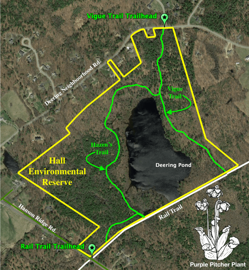
The public has a long history of access to the area. Innumerable citizens have related how they spent many enjoyable hours hiking, fishing, exploring, picking berries, etc. at the pond. On occasion a canoe or kayak can be seen on the pond. All traditional low impact uses will be allowed to continue. At one time the State of Maine was interested in creating a public launch area because Deering Pond is a Great Pond owned by the State of Maine, but the presence of visible and submerged rocks and ledges creates a serious hazard for motorized craft. The Indian name for the pond was Tombegawoc, “the pond of the rocky reefs.” Access to the pond is on the Sanford Rail Trail from Hanson Ridge Road or Oak Street. At Deering Neighborhood Road, there is a small parking lot on what is now called Vigue Road. This road leads down to ledges on the east side of the pond where there is a scenic overlook. It continues on to join the Rail Trail.
The pond itself is a tea colored, bog pond with floating mats of dwarf shrubs and sphagnum moss. The acid water rich in organic matter provides an aquatic habitat for a unique assemblage of uncommon plants and animals. Beavers have been present on and off for over forty years.
Trails:
Trails at Halls Reserve circumnavigate the Reserve’s centerpiece: Deering Pond. Two trailheads provide parking, and the trails are well marked. Hazen’s Trail is a ¾ mile footpath following the western shore area of the Pond, beginning about 500’ from the Rail Trail Trailhead at Hanson Ridge. First passing through a mixed beech, oak, and pine forest, then crossing the Pond’s outlet—marking the source of Branch River, also a Salmon Falls watershed source. From the outlet, hemlock become obvious, then suddenly the forest changes to a mixed oak, maple, beech hardwood stand. At this point, the trail follows a glacial rampart to the northern shore, passing over ribbon streams draining into the Pond, up an embankment, linking to the Reserve’s Vigue Trail. Turning south, Vigue Trail follows the eastern shore for about ⅓ mile to the Sanford Rail Trail, and a pleasant ½ mile walk back to the Hanson Ridge Road Trailhead; Turning north onto Vigue Trail for ⅕ mile leads to the Trailhead at Deering Neighborhood Road.
Management Plan:
- Implement the WoodsWise Stewardship Plan to improve habitat for species requiring early successional habitat.
- Provide more permanent markings for boundary lines to make monitoring for encroachment by adjacent landowners easier.
- Monitor water flowing into the pond from the housing development along Deering Neighborhood Road for nutrient loading.
- Repair trail damage and road erosion.
- Institute a series of regular field trips to the pond for public education.
- Acquire adjacent land that are extensions of the pond’s environment.
