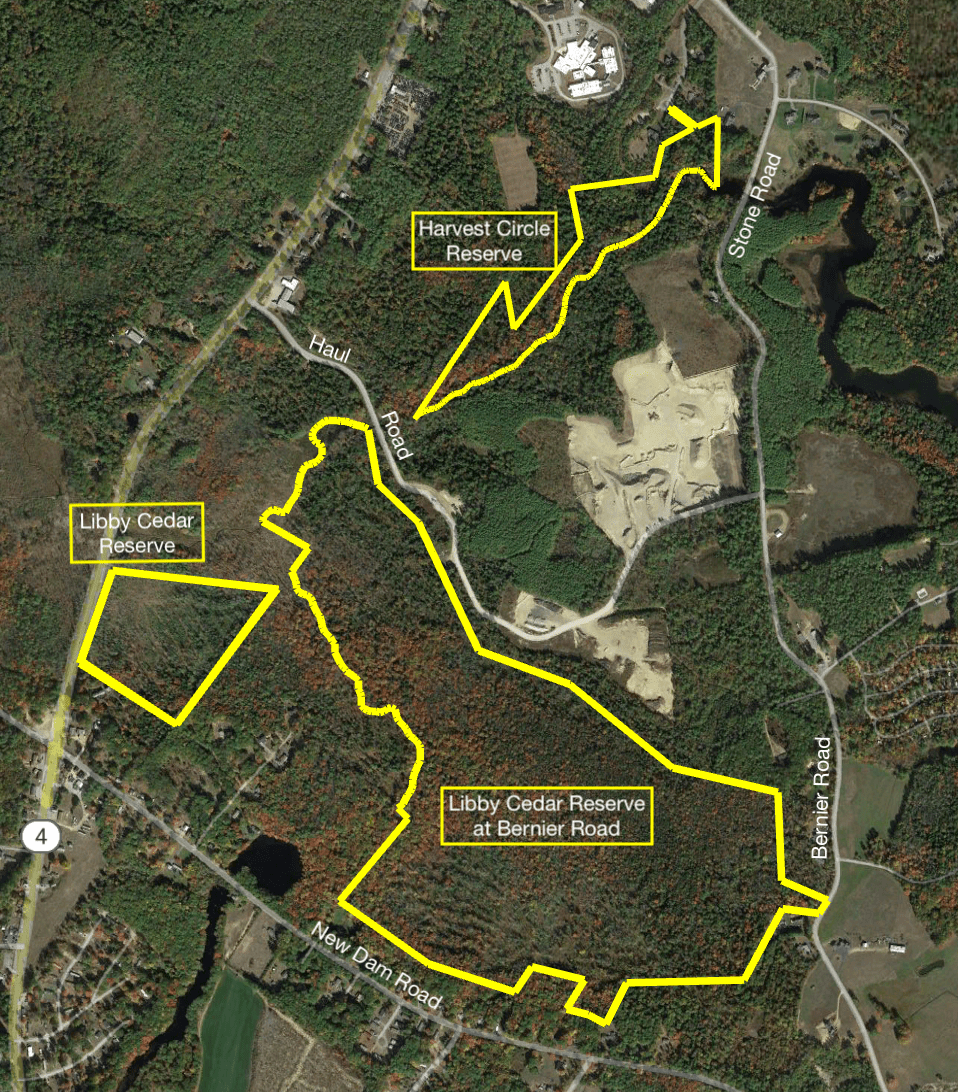
The Libby Cedar Reserve is our largest and most complex holding. It consists of 3 parcels comprised of 5 lots mostly separated from one another. Two lots combine to form the Harvest Circle Reserve, created to allow an open space area abutting a cluster housing development. This reserve abuts the Harvest Circle development to the north in Alfred, and the Sanford boundary at Hay Brook to the south. The Libby Cedar Reserve sits along Route 4, and is about 300 feet from the larger Libby Cedar Reserve at Bernier Road. The latter reserve was formed by 2 lots: access to the larger cedar swamp lot was provided by Dana Libby, a non-related, business associate of Robert Libby, who donated the lot abutting Bernier Road. Both Libby Reserves hold rare Atlantic white cedar swamps, described in more detail below.
Size Allocation: The 3 parcel Reserve totals about 200 acres. The Reserve lies within the area bounded by Route 4, and Bernier, New Dam, and the Hay Brook Haul roads. It is within the Hay Brook watershed which empties into Estes Lake. The flood control value of this wetland is enormous. Rain and melt water are absorbed and slowly released into Hay Brook, or evaporated into the air or stored in the surrounding sand and gravel aquifer. One inch of rainfall or melt water from ten inches of snow amount to roughly 5,400,000 gallons of water across the 200 acres of land. If this amount were to run off all at one time, downstream flooding and damage would be devastating.
History:
A number of people have owned parts of this group of lots. Otis Willard and his descendants had a farm near here. Barbed wire fences found on two lots provide evidence of farm pasture. Thomas Goodall owned the piece on Route 4 at one time. He had a brickyard somewhere in the vicinity. B.C. Jordan, lumber baron of Alfred, owned a major part of the lot with the cedar. William Farrar and David Stone later acquired and sold these parcels sometime in the 1940’s to Albert Lavalley who cut some of the cedar in the 1980’s. The Gile family owned the Bernier Road lot. All of these, but the Bernier Road piece, were purchased by North Country Land Company and donated to the land trust. The drier portions of the reserve probably have been cut over repeatedly since the first colonists arrived. In the late 1890’s it is quite likely that a large amount of cedar was cut for ties when the Atlantic Shore Trolley Line was constructed. The former route of the trolley line is not very far from the cedar stand. Most all of the larger trees outside of the cedar swamp on the parcels were removed in a 2007 harvest.
Significance:
Because there are many different soil types across the reserve, a large number of habitats exist here. A survey in the Massabesic Experimental Forest just across the river turned up an extensive list of plants, many of which are vanishing. Thus it is likely that many of the same species will eventually be found here. The cedar swamp is one of five large stands in York County and is a rare natural community in Maine. Rain and melt water are absorbed and slowly released into Hay Brook, or evaporated into the air or stored in the surrounding sand and gravel aquifer. One inch of rain falling on this reserve amounts to roughly 5,400,000 gallons of water. Melt water from ten inches of snow produces about the same number of gallons. If this amount were to run off quickly, downstream areas would suffer a devastating flood. Other ecological services provided by this reserve would include the probable recharge of the aquifer from which the Sanford Water District draws drinking water. Another service is the filtration of contaminants from the abandoned CGA site and septic systems along New Dam road. The large expanse of vegetation absorbs air pollutants and carbon dioxide
The soils in this area developed from fine sands deposited in an ancient glacial lake around a stranded block of ice. When the ice finally melted, it left a water-filled basin. Over many thousands of years peat accumulated in the basin, displaced much of the water and provided a surface for plants to grow upon. Today an Atlantic white cedar stand grows there.
Such a wetland forest community or swamp is a rare natural community in Maine and the cedar, itself is a species of “Special Concern”. Thanks to the generosity of Mr. Robert Libby, this valuable habitat is now preserved as a home for a wide range of animals and plants. The value of Atlantic white cedar to wildlife is not very well known, but some generalizations can be made on the basis of what is known about its close relative, northern white cedar or arborvitae. The foliage canopy offers cover, food and nesting sites for birds, red squirrels and flying squirrels. The stringy bark of the trunks is used by these animals for their nests. Insects undoubtedly feed on the foliage and in turn are eaten by the birds. The endangered Hessel’s hairstreak butterfly whose caterpillars eat only cedar foliage may be found here. Low growing plants provides food and cover for deer, moose and snowshoe hares.Drier brushy areas are suitable habitat for the rare New England Cottontail, the flood control value of this area is enormous. The thick spongy mat of sphagnum and other mosses that carpet the swamp most likely is home to other insects, amphibians, reptiles, mice and voles.
From the human perspective, the most significant values of this Reserve are the ecological services it performs in slowly releasing rain and melt water, the probable recharge of the aquifer from which Sanford’s Water District draw drinking water and the absorption of carbon dioxide, a major greenhouse gas, in exchange for oxygen. Since cedar foliage is evergreen, this process goes on through a major part of the year.
Future Plans For the Reserve:
In the near future the land trust will begin a long-term survey to determine what plants and animals are found there. Whenever possible ornithologists, entomologists, wildlife biologists and botanists will be invited to assist us in the survey. At the same time the swamp will be examined to determine if the creation of a trail is feasible and what route it might take. Also, the cedar research grant awarded to the land trust by the Davis Conservation Foundation will support studies on how best to manage the cedar to ensure its persistence into the future.
The land will be open to low impact use by the public such as traditional hunting and fishing. Trapping will be permitted with permission, particularly if beaver raise the water level. Cedar is killed by a prolonged high water level.
Management Plan:
- A WoodsWise forest management plan has been completed for these parcels. Although our plan spans ten years, the lack of mature timber because of a liquidation harvest by North Country Land Company will postpone most management activities for 20 to 25 years. In certain areas weeding, thinning and minor harvests to encourage wildlife will be done within ten years. Replanting also may be done where the stocking of seedling trees is low.
- A natural resource inventory of species present on these parcels will be instituted. This activity will take many years and the help of professional naturalists.
- Monitor the impact on water level of a downstream beaver dam on Hay Brook. A stable water level is critical to the survival of the cedar.
- Monitor the boundaries for encroachment by adjacent landowners and others.
Facts About Atlantic White Cedar, Chamaecyparis thyoides (L.) B S.P
Atlantic white cedar is a member of the cypress family to which the junipers, including red cedar, and Northern white cedar or arborvitae belong.
The foliage from the trees in an Atlantic white cedar swamp lets little light onto the forest floor, and the resultant cool dampness invites the growth of many types of mosses a few shrubs of blueberry and sheep laurel, herbs like cinnamon fern and starflower, and other plants that “like their feet wet” like skunk cabbage. This soil that is poorly drained and wet or damp most of the year, but rich in minerals and covered with a layer of peat holds the key to a healthy Atlantic white cedar habitat.
The wood of these trees is very resistant to rot and insect damage; this makes it quite valuable, and all of Maine’s forest stands have been previously harvested. In this area, many trees were cut to provide the wooden rail road ties of early rail roads and for wooden docks along the coast. These stands have now mostly reached maturity, and will succumb to being blown down due to weakness. Regeneration will be dependent upon keeping other tree species that like the same habitat from becoming established, like red maple, black ash, and hemlock. Historically, naturally occurring forest fires helped regeneration by burning the other trees which allows the seeds from the Atlantic white cedar to out-perform the germination and growing race in the wet, acid soil.
Here in southern Maine, Atlantic white cedar is at its northern-most range. Along with special soil, an elevation of less than 300 feet is needed, so this limits their habitat to the southern coastal plain, found between the ocean and the rolling hills of land further inland. In Maine, the southern forested wetlands are the only areas where such conditions are favorable, and southern Maine is experiencing rapid housing growth. Deer will eat seedlings when other food is scarce, but habitat loss is the major contributor to this species decline.
Atlantic White Cedar swamps are one of the rarest forest types in the eastern US. In Maine, it is given the rank of “S2”—“Imperiled”, and listed as “SC”, a species of “Special Concern”. This means the species will become endangered without protection from housing development growth. Although the forested wetland where Atlantic white cedar lives is recognized as imperiled, and some level of protection is offered, these rare habitats are imperiled by the encroachment of development along the dryer, easier to build upon upland borders of the swamp. The trees, shrubs, and other vegetation along the swamp’s border acts as a natural filter, helping to clean the air and water pollutants before they can enter the wetland. Also, the new homeowners tend to use fertilizers, bug sprays, and weed-killers on their lawns and landscaping; this added “run-off” enters the water and air stream into the swamp, further degrading the trees’ habitat. So the removal of Nature’s natural filter further imperils the cedars’ survival.
