After previous owners completed timber harvesting operations and decided to sell the land, conservation-minded landowners approached the Trust with an offer to act as “Conservation Buyers”, buying and holding land until the Trust’s fundraising efforts could reimburse them for the purchase price. Land acquisition was thus completed, and an additional block of land was donated to create the 110 acre McKeon Environmental Reserve.
Trails (map)
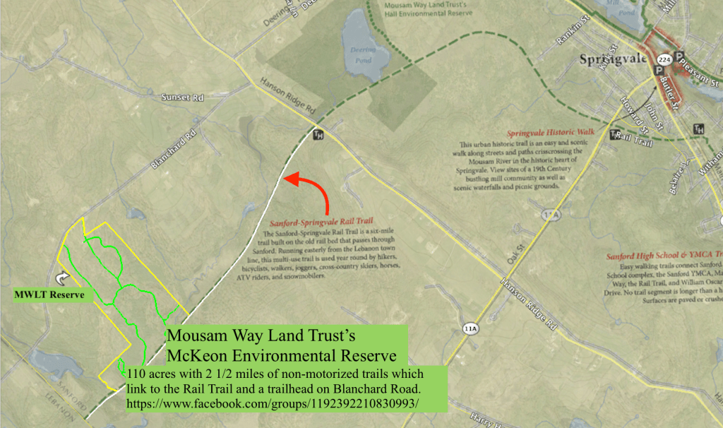
Previous timber harvests resulted in many skidder trails, which began receiving year round use by the locals. These 2 1/2 miles of trails are now also being discovered by the many folks using the linked “Rail Trail”, Sanford Trails 5 1/2 mile, multi-use and heavily used, re-purposed “Portland and Rochester Railroad Company” (1870) rail road bed. The Reserve’s linked trails traverse 4 types of Forested Wetlands, rolling uplands peppered with several large glacial erratic boulders, a meadow restoration project, and a very interesting Outcrop which forms a 25’ cliff plunging into the meandering, bird-rich Branch River, with views of the uplands to the north and west. A self-guided Nature Discovery Trail system will be incorporated into the existing trail system, having several dozen stopping points with placards and kiosks, offering information about plant and animal species, and geological, ecological, environmental and historical features. Benches will be located at strategic points. The hub of the previous wood harvests — a “wood yard” — is being restored into a pollination meadow, with close to 1,000 plants of many species already planted. A community home for the chimney swift, an increasingly rare bird, was built in the summer of 2021 as part of a Boy Scout Eagle project; This tower sits in the center of the meadow. The trail system is experiencing increased four-season use, with folks enjoying hiking, jogging, snowshoeing, biking, cross-country skiing, dog-walking, and of course wildlife watching, in all types of weather, in this ever-changing and regenerative, young forest environment.
An existing barn, drilled well, old but functional privy, and an adjacent field are being developed into The David and Linda Pence Community Ecology Center. Restoration of the barn will offer a place for meetings, workshops, and community functions. The adjacent field supports a vibrant community garden, with volunteer and oversight help from the York County Master Gardener Program, generously supported by Kennebunk Savings Bank. The field will also support a nursery for growing seedlings of native plants and trees to a size suitable for transplanting to this and other reserves. A greenhouse is also planned for horticultural instruction, demonstrations, and plant propagation. The existing deep-water well will provide a generous water supply for these functions. A modern ADA-accessible outdoor restroom has been constructed at the old privy site.
Community Engagement
Recognizing that MWLT engages in varied community-orientated projects, and that these projects most often involve local and regional participants performing educational, experimental, and restorative activities, often in off-trail and other relatively remote areas of the reserve, the traditional activity of hunting would pose an unacceptably high level of risk to these activities. Also, motorized vehicles would have a deleterious effect upon various restorative and regenerative efforts in areas of the Reserve. Therefore, the Trust has concluded that a “No Hunting”, “No Trapping”, and “No Motorized Vehicles” policy for the McKeon Reserve is in the best interest of both our vision for the reserve, and MWLT’s primary directives of environmental advocacy and awareness.
McKeon Reserve Management
The towns surrounding the Reserve’s location in southern York County support the homes of over 65,000 people; However much of that region is farmland and residential sprawl, so fertilizer and pesticide run off is a concern. Monitoring points for this would be the three culverts on Blanchard Road which drain the ridge to the north, and Branch River to the Reserve’s south which drains the larger ridges to the Reserve’s east..
The regional human population is discovering the Reserve’s outdoor and environmental recreational offerings: Trail use, Community Garden activities, and the various civic organizations’ involvement with educational, restorative, and recreational activities. These uses are welcomed and encouraged, and the Trust will actively engage with such activities whenever the opportunities arise. Such increased use will require increased monitoring to mitigate off-trail encroachment to wild areas, invasive plant introductions, vandalism, theft, and littering.
Previous timber harvests have resulted in the Reserve’s re-growth, to a rich young forest, and the several forested wetlands were left undisturbed from previous wood harvests; This combination has generated a vibrant ecosystem, diverse with wildlife—especially birds. The varying topography and forest types, along with a complimentary surrounding forested landscape, offer an ideal area for maintaining this Reserve as a “Forest For Maine Birds” area. Therefore, all silvicultural treatments, forestry operations, and/or vegetative removals will be directed towards the betterment of habitats as described in the Forestry For Maine Birds program—a collaborative effort of Maine Audubon, the Forest Stewards Guild, the Maine Forest Service, and the Maine Department of Inland Fisheries and Wildlife—or a similar Audubon program. All such activities, when deemed appropriate by Mousam Way Land Trust, will be planned, designed, and coordinated with consideration given for Maine Audubon Society advise.
Also, all vegetative matter disturbed, cut, or otherwise affected, is to remain where it lays; This is in recognition of the many forest ecosystem processes positively affected by plant decay, including but not limited to: Wildlife enhancement, organic matter and nutrients improving soil structure and vitality, moisture retention, carbon sequestration, and mycorrhizal growth and support. Also, this requirement is added to remove the temptation to prioritize monetization of treatments/forestry operations/vegetative removals. All stone walls will remain intact and undisturbed.
All Reserve land will be stewarded as above, except for the following, as delineated on the attached Land Use Map:
The Trails—Motorized vehicular use is allowed on the trails for trail and Reserve maintenance only, and for access to the Sanford City Rail Trail via the Meadow-to-Center trails;
The Meadow—This approximate 2½ acre area, bounded Westerly and northerly by a stone wall, southerly by a geologic sandy kame formation, and easterly by a wetland area and trail culvert, will be maintained as a meadow and signed “Patty’s Garden of Wings”.
David & Linda Pence Community Ecology Center—This approximate 1⅔ acre area is bounded by Blanchard Road to the north, Center Trail to the east, and the stone wall running northwesterly from the Center Trail back to Blanchard Road. The Pence Center is the hub of the Reserve’s human activity. Along with the actual Community Center building, this area holds the Sanford Community Garden, the Mike Terro and Kelly Tarbox Greenhouse, the Dave Jagger apiary, an outdoor restroom, a drilled-well water supply, a trailhead, and Reserve parking. Facility and land use within this area is for environmental awareness advocacies including but not limited to education, meetings, outdoor events, horticultural advocacy, and promotion of natural resource conservation.

2 responses to “McKeon Environmental Reserve”
[…] applications. The Garden is part of the David and Linda Pence Community Ecology Center at the McKeon Environmental Reserve in […]
LikeLike
[…] applications. The Garden is part of the David and Linda Pence Community Ecology Center at the McKeon Environmental Reserve in […]
LikeLike